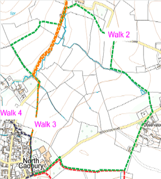
Map showing the route of the walk as described below
Route 2 from Village shop to Woolston and return (about one and a half hours)
From NC Village shop turn left (east) towards Woolston along road for about 200 m.
Follow finger post on right (concrete track) and take WN19/96 on right (east).
Follow track and then path (east) to where WN19/81 turns 90° to north.
Follow WN19/81 along field boundary, to join track in corner of field.
Continue straight ahead (north) along track and emerge onto Woolston Road.
Turn right and almost immediately left onto WN19/85.
Cross bridge at far end of field boundary.
Take WN19/84 left (north west) and follow field boundary.
Go through copse in far corner of field, over stile and sharp left along field boundary to second stile.
Path turns right (north).
Emerge through metal 'Bristol' gate onto Corkscrew Lane.
After 100 m. follow finger post to left and join WN19/43 along field boundary.
At corner of hedge turn 45° to north west diagonally across field to gate and stile.
Over stile and continue to gate and stile onto Corkscrew Lane opposite Brickhouse Farm.
Turn left and left again at small bridge.
Walk along lane to stile on right (about 50m) and join WN19/54.
Walk straight ahead (west) across field to corner of hedge on left.
Cross small bridge hidden in hedgerow and follow field boundary to left (south west) to junction with WN19/103, WN19/104 & WN19/53.
Turn left (south) onto WN19/103 which emerges onto Sandbrook Lane.
After 100 m turn right on bend, take stone steps to left onto WN19/65 and walk diagonally (south west) across field, then through small gate in corner of field, onto WN19/66, straight ahead through second small gate alongside school playing field onto WN19/107.
At junction with path, keep straight ahead on path WN19/67 over small bridge and gate, across field and through gate.
Where path divides, bear left onto WN19/67. Follow track to Woolston Road and shop (on left).
The interactive Rights of Way map, not only maps all footpaths and bridleways and restricted byways, but walkers can report where they find faults with stiles etc. and cross cropping of paths.
The Countryside Code helps give balance with regard to the relationship of public rights over private land and encourages responsible use of the routes.
Funded by Somerset Community Grant & donation from The Newt