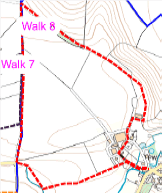
Map showing the route of the walk as described below
Route 8 from Car park by Church and return (about one hour)
With back to church exit car park and turn right to enter Pound Lane on right between houses.
Walk about 50m to gate and finger post on left, signed Stoke Lane.
This is WN31/8.
Take this path and walk straight ahead (west) across field, to far hedgerow.
Cross stile and continue in same direction to far field boundary.
Cross stile onto Stoke Lane.
Turn right (north) on lane.
On sharp left bend in lane continue straight ahead slightly uphill on WN19/97 (Hick’s Lane).
Pass gate on left leading to WN19/100, but carry on straight ahead.
After 75 m ignore fingerposts for WN19/27 & WN19/28 to the left (west) and WN31/9 to the right (east).
Proceed along track about 50 m to sharp left bend of track.
Turn right (east) at finger post through large metal gate onto WN31/10.
Walk track and through three gates.
Emerge into field.
Straight ahead, across field and through small metal gate.
Turn right in front of barn.
Turn left at end of barn.
Walk through farmyard bearing left between buildings and emerge onto Pound Lane.
Walk short distance to end of lane.
Turn left to car park.
The interactive Rights of Way map, not only maps all footpaths and bridleways and restricted byways, but walkers can report where they find faults with stiles etc. and cross cropping of paths.
The Countryside Code helps give balance with regard to the relationship of public rights over private land and encourages responsible use of the routes.
Funded by Somerset Community Grant & donation from The Newt